


CHAPTER B2 – FOREST AREA
| CHAPTER B2 – FOREST AREA | STATUS & REVISION HISTORY | ||
|---|---|---|
| Original Standard | May 1999 | NZIF April 2019 revisions:
|
| Review by Forestry Australia Valuation Working Group | Sept 2020 | Main revisions are:
|
| CURRENT STATUS | July 2025 | Released as final |
PDF available to download here
Purpose
The purpose of the standard is to ensure that:
- all area information relevant to the uses for which the forest description is prepared is disclosed;
- area measurement and conventions are declared;
- the reliance placed on the non-confirmed area measurement is declared;
- the estimated accuracy of the area statement is declared, and the potential impact any lack of accuracy may have on information derived from the forest description is disclosed; and
- area measurement is consistent with yield measurement.
Standard B2.1 – Declaration of areas
The forest description shall declare the following areas:
- in the case of land that is described on a Certificate of Title, the legal title areas upon which the forest is located;
- in the case of land that is legally under the use of the forest owner and for which a surveyed area is known, but the land is not described on a Certificate of Title, the declared total land area and the source of that area information *;
- total land contained within the forest description, including any land not included within the area legally occupied * and outside the property’s external legal boundaries, as covered by the above;
- a breakdown of areas within the forest description into classes relevant to the uses of the forest description – as a minimum this shall include:
Plantation forests:
a) Potentially Plantable Area (PPA):
− currently stocked (Net Stocked Area – NSA)
− area prepared for planting
− area not prepared but intended for planting
b) non-Productive Area:
− other area;
Natural forests:
a) gross area:
b) harvestable or utilisable area
− categorisation by harvest history / intensity
− areas to be scarified / seeded post harvesting
c) conservation areas (stream buffers, riparian zones etc) a breakdown of, or reference to, areas that are not legally occupied, but are within the forest description and outside the property’s external legal boundaries, into the above categories; and
• where material, the likely changes in potentially plantable area from one rotation to the next including increases (e.g. replanting of previously failed areas) or decreases (e.g. increased setbacks).
* In the case of Crown land this may include Crown records and/or Crown lease areas.
* There are rare instances in Australia where area is assigned for legal reasons, but harvest volumes are pooled from larger areas, as is the case with ex management investment scheme areas now converted to institutional or other private ownership.
Standard B2.2 – Stocked area measurement
For describing the way in which the Net Stocked Area (NSA) was determined and checked, the forest description shall:
- describe the method of area definition and measurement or source of area information, together with a description how those areas have been assessed.
Standard B2.3 – Area reconciliation
For reconciling reported areas to known areas, the forest description shall:
- declare whether or not measured areas have been reconciled by measurement and summation of all areas within a legal title or known surveyed area; and
- declare whether or not areas have been reconciled with areas recorded in any forest record system upon which the forest description relies.
Standard B2.4 – Reliance on areas supplied by others
Where reliance has been placed on area information sourced from third parties (including the forest owner), the forest description shall describe the procedures undertaken to verify such information.
Standard B2.5 – Statement of reliability
An estimate of the accuracy of stocked area statements shall be provided, along with the source of that estimate.
Standard B2.6 – Consistency with yield measurement
Forest area measurement conventions shall be consistent with conventions used for the estimation of yields.
Standard B2.7 – Mapping Forest Land for Carbon sequestration
In Australia mapping for all projects under the Carbon Credits (Carbon Farming Initiative) Act 2011 should comply with the Carbon Farming Initiative (CFI) Mapping Standards produced by The Department of the Environment and Energy.
In New Zealand all mapping of post-1989 forest land, as defined by the Climate Change Response Act (CCRA) 2002 for registration in the Emission Trading Scheme (ETS) must be completed in accordance with the Geospatial Mapping Information Standard, ‘the Mapping Standard’, issued under the authority delegated to the Chief Executive of the Ministry for Primary Industries (MPI).
GUIDANCE NOTES ON NET STOCKED AREA STATEMENT
Importance of area in forest valuation
Forest value is closely related to reported stocked area.
There will be a trade-off between the value of having a more precise area statement and the cost of obtaining it. Thus, the purpose of the forest valuation and potential impact of not having precise areas must be known.
An appreciation of the confidence that should be placed on any area statement can be extremely important to the user of a forest valuation.
Gross land area
Gross land area may be sourced from:
- In Australia, the surveyed area as defined on a Certificate of Title, survey Plan approved by the respective State’s Surveyor General or in the case of Crown land, Crown Leases or Crown Records; and
- In New Zealand, from the surveyed area as defined on a Certificate of Title, Survey Plan approved by the District Land Registrar, Cadastral Record Map, or in the case of some Crown Land and Maori Land, from other documents.
Legally occupied
The term ‘legally occupied’ in the standard for declaration of areas means: that area to which the forest owner has legal title or occupation rights of some form.
Areas that are not legally occupied would be stocked areas on, for example:
- unformed legal roadways (in New Zealand belonging to the local District Council);
- neighbouring property as a result of fenced boundaries that do not follow legal boundaries; and
- accretion areas on river boundaries.
In New Zealand areas not legally occupied, such as unformed legal roadways and accretion areas on river boundaries, are commonly harvested together with the adjacent areas without consent from the local District Council or the Crown. Thus, while not ‘legally occupied’ these areas may be included in the forest valuation and the stocked area statement.
Tree crop areas situated on neighbouring property for which there is no legal agreement of ownership, such as a lease, forestry right or other agreement, must be disclosed and excluded from the forest valuation and the stocked area statement where material.
Wide variation in reliability
The determination of an NSA may range from extremely precise (photogrammetric survey) to extremely rough (eyeball estimate or measurement off uncorrected aerial photograph).
Given the many factors that can influence the reliability of any area statement, it is impossible to provide any guideline that could be applied with confidence to individual cases. The safest approach is to seek advice from a qualified expert about the likely reliability of any area statement on a case-by-case basis.
However, it is recognised that expert opinion will not be readily available in all cases. Experts who are working full-time in the field of forest area measurement can draw on their experience, using various mapping and measurement techniques, to provide some guidance.
These notes give some background and the guidance provided by such experts.
Selection of method of determining area
The method selected for area determination will depend on the precision required, as well as the size, terrain, location, access and age class distribution of the block.
The methodology used to determine the area should reflect the size and value of the stand and the purpose for which the forest description is being prepared. Consideration should be given to longer-term management requirements when deciding on mapping methods.
Area measurement conventions
The measurement of forest area needs to follow conventions that are consistent with the determination of yield. These conventions must cover, as a minimum:
- inclusion or exclusion of stocking gaps (depending on yield conventions);
- if excluded, the minimum size stocking gap recognised (usually 0.1 ha for stocked area mapping);
- inclusion or exclusion of forest roads, reserves, or other unstocked areas; and
- definition of stocked area boundary (stem, edge of crown, or some intermediate distance between the two). This must be consistent with forest inventory practice.
Area measurement from ground survey
The area may be determined directly from ground survey data without reference to a map.
Ground surveys can be completed by a chain and compass survey, Global Positioning System (GPS) or a full theodolite survey.
The accuracy of a ground survey is dependent on the method used.
Area measurement from maps, photographs or remotely sensed data
Maps can be produced using a variety of methods. For the purposes of measuring stocked areas, a map may consist only of stocked boundaries or of stocked boundaries transferred to accurate base mapping. Accurate base mapping uses one or more of the following methods or sources of information:
- photogrammetric mapping, orthophotos or satellite imagery;
- GPS survey;
- LiDAR data;
- national datasets;
− Australia the data sets are organised at state level, resolution varies by state and location within states but range from 1:25,000 upwards
− New Zealand the LINZ Topo50 map series database; and - conventional survey.
- Maps showing stocked area boundaries only, or transferring stocked area boundaries to a base map, can be completed using one or a combination of the following methods:
- photogrammetric mapping, orthophotos, remotely sensed data;
- GPS survey;
- ground survey; and
- visual transfer.
The accuracy of area measurement using these options will depend on:
- the accuracy and content of the base map;
- the accuracy of the method used to transfer stocked area boundaries to the base map; or
- in the case of a map showing stocked area boundaries alone, the accuracy of the method used to produce the map. For most valuation purposes, geo rectified aerial photography (as opposed to ortho-rectified aerial photography), enlarged small scale maps and non-corrected aerial photography are not suitable for base map production or for direct area measurement without further controls to check accuracy. The use of these for area measurement should be limited to the purposes of valuation where the accuracy of the area measurement (and by implication the confidence the reader can place in the reported value) is not important.
Area measurement techniques
Measurement of areas on maps can be made using:
- Geographic Information Systems (GIS) or other survey software;
- digital electronic planimeter; or
- dot grid.
The accuracy of the measurement is dependent on:
- the accuracy of the base map information;
- the accuracy of the superimposed boundary (e.g. the forest boundary); and
- the skill of the operator.
There are no major differences in precision for each of the four methods, but a dot grid is not a practical solution for a large area.
Reliability tables
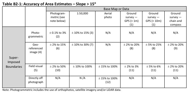
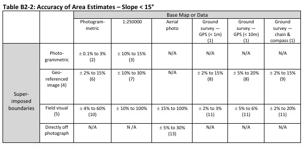
Tables B2-1 and B2-2 provide indicative estimates of the accuracy that could be attached to areas determined by a variety of commonly used base map and stocked area definition techniques. Note that the tables have no scientific basis, as the accuracy of a measured area can only be estimated on a case-by-case basis from the known accuracy of individual point locations. The tables have been derived from the experience of forest draughting practitioners who have been involved in forest area mapping on the same tract of land over time using different techniques. In most cases the range provided is necessarily wide, as many factors will influence accuracy.
Block size:
The percentage error will tend to increase for smaller blocks.
Scale:
Error of definition of stocked boundaries and area measurement will be relatively less (better) using remotely sensed data, aerial photography or mapping at high resolution (e.g. 1m pixels or small scale e.g. 1:10,000) and relatively greater (poorer) at low resolution (10m pixels or large scale e.g. 1:100,000).
Topography:
The potential for error is much greater on steep and/or broken terrain. In an attempt to remove the potentially large influences of these key variables, the following (block size, block shape, scale of mapping and slope) have been defined:
Table B2-1
100 ha
1:10,000 photography and/or map scale
Multiple slopes > 15°
Table B2-2
As for Table B2-1 except:
Multiple slopes < 15°
Notes to reliability tables
Every method used to assess areas that require image interpretation needs to be applied by a skilled and experienced operator or checked by such an operator. Poor image quality and/or poor image interpretation can lead to inaccuracies that exceed the estimated accuracy limits presented in the tables above.
The following notes refer to the tables above:
- GPS or ground survey may be used to define external boundaries or control points and combined with aerial photo interpretation for internal boundaries. The quality of GPS instruments varies widely. Data point precision is typically ± < 1m to ± 10 m.
- The accuracy limits provided presume adequate ground control. A relatively inexpensive option to get an excellent stocked area statement is to request a professional mapping firm to undertake a planimetric survey of the stocked area without contours. However, such a survey will not serve the other management needs that a contour map provides. Also, delay times can be a constraint for valuation purposes.
- This combination is not commonly used.
- A geo-referenced image refers to an aerial photo or satellite image that is not ortho-rectified. This includes Small Camera Aerial Photography (SCAP).
- The transfer of stocked boundaries is most accurate when trees are clearly visible on the aerial image. However, for new plantings visual field assessment is usually the only option (unless an image showing sprayed spots is available). The quality of this assessment, combined with experience on likely area losses, will have a significant impact on the reliance that can be placed on this estimate relative to areas subsequently measured off aerial images.
- This is a commonly used technique for updating stocked areas on photogrammetric base maps in the forest industry. Precision will be greatest on easy contours with good control over alignment of photographic features with the base map. If the topographic information shown on the base map is insufficient to provide adequate control, this method could lead to errors substantially greater than 15%.
- It is recognised as a quick and inexpensive method, but is potentially highly inaccurate, due to the compilation scale and generalised content of the base map.
- GPS gives good control of external boundaries and potentially internal stocking gap boundaries. The main source of error is typically in the transfer of internal stocking gaps from aerial images that are not ortho rectified.
- Accuracy depends mainly on the quality of the compass, the skill of the field survey crew and the calibration of the tape or chain. The application of appropriate ‘closing’ techniques is also critical.
- The main source of error using this technique is the performance of the person marking the stocked boundaries in the field, including internal stocking gaps. Influencing factors are the quality and detail of the base map, the state of the ground cover, and ease of access to and viewing of all stocked area boundaries.
- A boundary survey combined with a visual assessment of stocked area boundaries is only suitable for smaller blocks where internal stocking gaps are insignificant. The error limits estimated are for external boundaries only (i.e. assumes full stocking to surveyed perimeter).
- Accuracy depends on many factors:
• ground contour;
• scale of photo;
• resolution of imagery;
• position of forest relative to centre of photograph; and
• tilt of camera. - Accuracy will be greatest on large-scale photographs that allow precise scaling. This is an inexpensive technique for relatively flat ground where the block is centrally located on the photo.
- Scale may be determined by direct measurement on the ground (distance between features visible on the photograph) or from flight and camera specifications.
Differences between forest stocked areas and carbon accounting areas
In Australia, estimates of land suitable for registration under the Emissions Reduction Fund (ERF) are likely to differ from NSA estimates. When applying to register an area under the ERF, the mapping must be undertaken in accordance with the Carbon Farming Initiative (CFI) Mapping Standards produced by The Department of the Environment and Energy.
In New Zealand estimates of eligible post-1989 forest land areas as defined by the Climate Change Response Act (CCRA) 2002 are likely to differ from NSA estimates. When applying for Carbon Accounting Areas (CAAs) for the Emission Trading Scheme (ETS) or assessing areas of deforestation in relation to pre-1990 forest land, the forest mapping must be completed in accordance with the Geospatial Mapping Information Standard, ‘the Mapping Standard’, issued under the authority delegated to the Chief Executive of the Ministry for Primary Industries (MPI).
Australian topographic map references
ACT: http://www.actmapi.act.gov.au/home.html
NSW: https://www.spatial.nsw.gov.au/products_and_services/topographic_maps
NT: https://denr.nt.gov.au/land-resource-management/info-systems/naturalresource-maps/nr-maps-information
QLD: https://www.business.qld.gov.au/running-business/supportassistance/mapping-data-imagery/maps/topographic-maps
SA: https://www.environment.sa.gov.au/topics/Science/mapland/maps/topographic-cadastral
TAS: https://dpipwe.tas.gov.au/land-tasmania/tasmap
VIC: ://www.delwp.vic.gov.au/maps/maps-and-services/vicmaptopographic-maps
WA: https://www0.landgate.wa.gov.au/maps-and-imagery/topographic-maps
Last date updated: 31/07/2025